[other]PnPoly (Ray Casting Algorithm)結合google maps api(搭配一點jQuery mobile)
前言
其實這功能當初只是被指定給予一個些特定座標畫出一個多邊形後判斷指定點是否包含在內,但基於鄉民個性覺得有圖有真相,所以就結合google.maps.api以及jQuery mobile的介面做了一個簡單的範例。
原理
Point in Polygon (Ray Casting Algorithm)這是一個計算某一特定點(point)是否包含於一個指定多邊形(Polygon)內的演算法,概念可以透過以下圖解。
點包含在範圍內:
點不包含在範圍內:
總結上面的圖片我們可以得知:
從給定點開始,往隨便一個方向,射出一條無限長射線,看看穿過多少條邊,如果穿過偶數次(2,4,6…ect),表示點在簡單多邊形外部;如果穿過奇數次(1,3,5…ect),表示點在簡單多邊形(邊不相交的多邊形)內部。
在此我參考了一段由W. Randolph Franklin透過C 寫的程式碼
int pnpoly(int nvert, float *vertx, float *verty, float testx, float testy)
{
  int i, j, c = 0;
  for (i = 0, j = nvert-1; i < nvert; j = i++) {
    if ( ((verty[i]>testy) != (verty[j]>testy)) &&
	 (testx < (vertx[j]-vertx[i]) * (testy-verty[i]) / (verty[j]-verty[i]) + vertx[i]) )
       c = !c;
  }
  return c;
}
正題
透過上面的程式碼,我再結合了goolge.maps.api把輸入的點畫出來,並將指定的判斷點呈現在地圖上讓你肉眼既可以看出該點是否被依指定多邊形所包含。
透過下面這段程式碼我們可以將各點兩點相連成線構成一個簡單多邊形
	var area = new google.maps.Polyline({
				path: areasLine,
				strokeColor: "#FF0000",
				strokeOpacity: 1.0,
				strokeWeight: 2
				});
稍微注意一下上面的areaLine是一個google.maps.LatLng的陣列,而為了畫出簡單多邊形,最後記得要將終點連回起始點(頭尾相連)程式有補上(頭尾相連)。舉例來說如果要呈現下圖的四個點的樣子
那我們就必須將下列的座標點已google.maps.LatLng的物件方式做成一組陣列,如下:
			areaPolygon.push(new Point(24.781825,121.003375));
			areaPolygon.push(new Point(24.794663,120.972626));
			areaPolygon.push(new Point(24.774987,120.985415));
			areaPolygon.push(new Point(24.769298,121.002753));

			  	for (var i = areaPolygon.length - 1; i >= 0; i--) {
					areasLine.push(new google.maps.LatLng(areaPolygon[i].x,areaPolygon[i].y));
				};
				//寫入頭/尾點使它成為簡單多邊形
				if(areaPolygon.length>2){
					areasLine.push(new google.maps.LatLng(areaPolygon[areaPolygon.length-1].x,areaPolygon[areaPolygon.length-1].y));
				}
另外,我在介面上透過google.maps.event.addListener來監聽滑鼠移動(即時顯示當前座標)跟左鍵按下時(取得點下當下的座標)的事件,寫法如下:
			google.maps.event.addListener(map,'mousemove',function(event)
			{
				center = event.latLng;
				$('#txtLat').val(center.lat());
				$('#txtLong').val(center.lng());
			});
			google.maps.event.addListener(map,'click',function(event)
			{
				center = event.latLng;
				$('#txtLatLongOnClicked').val(center.lat() + ', ' + center.lng());
			});
結果(畫面)
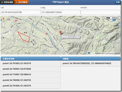
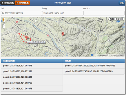
最後的結果就是下面這樣,頁面載入預設會帶入四個寫死的點,透過左上方的新增判斷點你可以加入指定點做判斷是否在目前呈現的多邊形當中,而透過滑鼠在地圖上移動可顯示目前座標而點選滑鼠左鍵則會記錄當前座標顯示在onclick的欄位中。
使用上可以將預設點註解後透過介面的新增區域點來畫圖,這邊之後會再補上刪除點的版本已經補上更新。
另外,第一次使用新增區域點或是判斷點都會讓地圖的render有問題,這邊要按一下左上角的更新即可,查了一下好像是地圖還沒產生或是使用上順序不對才導致地圖出現有問題,這邊有人能指導一下該如何修改的話我會非常感激你~~~
以上心得分享給對於這塊也有相同問題的偉大程式設計師們!
完整程式碼
<!DOCTYPE html>
<html><!-- manifest="cache.appcache" 開啟Cache 功能-->
    <head>
        <meta http-equiv="Content-Type" content="text/html; charset=UTF-8"></meta>
        <!--jQuery-->
        <script type="text/javascript" src="js/jquery-1.8.2.min.js"></script>
		<!--json2-->
		<script type="text/javascript" src="js/json2.min.js"></script>
		<!--Google Map API v3-->
		<script type="text/javascript"	src="https://maps.googleapis.com/maps/api/js?key=AIzaSyDE9qxWxKreYH34oRyk2RCtM5-VqrauTPc&sensor=false"></script>
		<!--jQuery mobile-->
        <link rel="stylesheet" type="text/css" href="css/jquery.mobile-1.3.0.css"></link>
        <script type="text/javascript" src="js/jquery.mobile-1.3.0.min.js"></script>
        <!--Style-->
        <style type="text/css">
		body, html {
		  height: 100%;
		  width: 100%;
		}
		div#map_canvas {
		  width: 100%; height: 300px;
		}
		#map_canvas img { max-width: none; }

        </style>
		<!--Test script-->
		<script>
		var areaPolygon=[];
		var spots=[];
		function insertPoint(point,Type){
			var content;
			if(Type=="spot"){
				spots.push(point);
			}else{
				areaPolygon.push(point);
			}
		}
		function deletePoint(index,Type){
			var content;
			if(Type=="spot"){
				spots.splice(index,1);
			}else{
				areaPolygon.splice(index,1);
			}
		}
		function ini(){
			areaPolygon=[];
			spots=[];

 areaPolygon.push(new Point(25.0349120393757, 121.5126085281372));
 areaPolygon.push(new Point(25.03191797702558, 121.51453971862793));
 areaPolygon.push(new Point(25.032151283210304, 121.51556968688965));
 areaPolygon.push(new Point(25.034523204238038, 121.51505470275879));


// areaPolygon.push(new Point(25.0314513633252, 121.51488304138184));
// areaPolygon.push(new Point(25.029895971507845, 121.51552677154541));
// areaPolygon.push(new Point(25.029973741567, 121.51651382446289));
// areaPolygon.push(new Point(25.0314513633252, 121.51548385620117));
			spots.push(new Point(25.030168166499184, 121.51793003082275));
			spots.push(new Point(25.033162271550825, 121.51458263397217));
			spots.push(new Point(25.030362591123314, 121.5157413482666));
			// spots.push(new Point(25.0574,121.5457));
			// spots.push(new Point(25.0435,121.5178));
			// spots.push(new Point(25.0571,121.5085));
			refresh();
		}
		function refresh(){
			map_initialize(areaPolygon,spots);
			//清單
			showPointList($('#spotList'),spots,"判斷點");
			showPointList($('#areaList'),areaPolygon,"多邊形區域點");
		}
		function showPointList(div,points,name){
			var html="";
			if(points.length>0){
				html+="<li data-role='list-divider'>"+name+"</li>";
				for(var index=0;index<points.length;index++){
					html+="<li>point"+(index+1)+":"+points[index].x+","+points[index].y+"<button data-inline='true' class='btnDelete' data-index='"+index+"'>delete</button></li>";
				}
			}
			$(div).html(html);
			//CSS需套用才能正確呈現
			$(div).listview("refresh");
			$('.btnDelete').button();
		}
		function Point(x,y){
		    this.x=x;
		    this.y=y;
		}
		function isPointInPoly(poly, pt){
			for(var c = false, i = -1, l = poly.length, j = l - 1; ++i < l; j = i)
				((poly[i].y <= pt.y && pt.y < poly[j].y) || (poly[j].y <= pt.y && pt.y < poly[i].y))
				&& (pt.x < (poly[j].x - poly[i].x) * (pt.y - poly[i].y) / (poly[j].y - poly[i].y) + poly[i].x)
				&& (c = !c);
			return c;
		}
		function map_initialize(areaPolygon,spots) {
			var myLatLng= new google.maps.LatLng(24.78991,121.005757);
			if(spots.length!=0){
			myLatLng = new google.maps.LatLng(spots[0].x,spots[0].y);
			}
			var mapOptions = {
			zoom: 12,
			center: myLatLng,
			mapTypeId: google.maps.MapTypeId.TERRAIN
			};

			var map = new google.maps.Map(document.getElementById("map_canvas"),
			  mapOptions);
			var areasLine = [];

			  	for (var i = areaPolygon.length - 1; i >= 0; i--) {
					areasLine.push(new google.maps.LatLng(areaPolygon[i].x,areaPolygon[i].y));
				};
				//寫入頭/尾點使它成為簡單多邊形
				if(areaPolygon.length>2){
					areasLine.push(new google.maps.LatLng(areaPolygon[areaPolygon.length-1].x,areaPolygon[areaPolygon.length-1].y));
				}
			  	for (var i =0;i< spots.length;i++) {
				  	  var coordinate = new google.maps.LatLng(spots[i].x,spots[i].y);
					  var marker = new google.maps.Marker({
				      position: coordinate,
				      map: map,
				      title:"spots:"+(i+1)+",是否在區域內:"+(isPointInPoly(areaPolygon,spots[i])?"是":"否")
				  });
				};
				var area = new google.maps.Polyline({
				path: areasLine,
				strokeColor: "#FF0000",
				strokeOpacity: 1.0,
				strokeWeight: 2
				});
				area.setMap(map);
			google.maps.event.addListener(map,'mousemove',function(event)
			{
				center = event.latLng;
				$('#txtLat').val(center.lat());
				$('#txtLong').val(center.lng());
			});
			google.maps.event.addListener(map,'click',function(event)
			{
				center = event.latLng;
				$('#txtLatLongOnClicked').val(center.lat() + ', ' + center.lng());
			});
		}
		$(document).on('pageini','#index',function(){
		});
		$(document).on('pageshow','#index',function(){
			refresh();
			$('#areaList').on('click','.btnDelete',function(){
				var index=$(this).data("index");
				areaPolygon.splice(index,1);
				 refresh();
			});
			$('#spotList').on('click','.btnDelete',function(){
				var index=$(this).data("index");
				spots.splice(index,1);
				 refresh();
			});
		});
		$(document).on('pageshow','#popupAddAreaPoint',function(){
				$(this).find('#txtLatitudeLongitude').val('');
		});
		$(document).on('pageshow','#popupAddSpotPoint',function(){
				$(this).find('#txtLatitudeLongitude').val('');
		});
		</script>
	</head>
    <body onload="ini();">
		<!--首頁-->
		<div data-role="page" id="index">
			<div data-role="header" data-theme="f">
				    <div class="ui-btn-left" data-role="controlgroup" data-type="horizontal">
				<a data-icon="add" data-role="button" data-theme="a" data-transition="pop" data-position-to="window" href="#popupAddAreaPoint" data-inline="true">新增區域點</a>
				<a data-icon="add" data-role="button"  data-theme="e" data-transition="pop" data-position-to="window" href="#popupAddSpotPoint" data-inline="true">新增判斷點</a>
				    </div>
                <h1>PNPolygon 測試</h1>
                <div data-role="controlgroup" class="ui-btn-right" data-type="horizontal">
                <button onclick="refresh();">更新</button>
				</div>
            </div>
			<div data-role="content">
			<div>
			 	<div class="ui-grid-b">
				    <div class="ui-block-a" >    Lat:<input type="text" id="txtLat"></text></div>
				    <div class="ui-block-b" >   Long:<input type="text" id="txtLong"></text></div>
				    <div class="ui-block-c" >onclick:<input type="text" id="txtLatLongOnClicked"></text></div>
				</div>
				<div id="map_canvas">
			 	</div>
			 	<div class="ui-grid-a">
				    <div class="ui-block-a" ><ul id="areaList" data-inset="true" data-role="listview"></ul></div>
				    <div class="ui-block-b" ><ul id="spotList" data-inset="true" data-role="listview"></ul></div>
				</div>
			</div>
			</div>
		</div>
		<!--popup-->
	    <div data-role="popup" id="popupAddAreaPoint" data-theme="a" class="ui-corner-all">
	        <form>
				<div style="padding:10px 20px;">
				  <h3>add area pologon point(新增區域點)</h3>
				  <input type="text" id="txtLatitudeLongitude" value=""  placeholder="latitude(緯度),longitude(經度)" data-theme="a">
				<div class="ui-grid-a">
					<div class="ui-block-a" ><button id="btnAddArea" data-theme="f" data-icon="check">add</button></div>
					<div class="ui-block-b" ><a data-theme="b" data-role="button" data-icon="back" data-rel="back">cancel</a></div>
				</div>
				</div>
	        </form>
	    </div>
	    <div data-role="popup" id="popupAddSpotPoint" data-theme="a" class="ui-corner-all">
	        <form>
				<div style="padding:10px 20px;">
				  <h3>add spot point(新增判斷點)</h3>
				  <input type="text" id="txtLatitudeLongitude" value=""  placeholder="latitude(緯度),longitude(經度)" data-theme="a">
				<div class="ui-grid-a">
					<div class="ui-block-a" ><button id="btnAddSpot" data-theme="f" data-icon="check">add</button></div>
					<div class="ui-block-b" ><a data-theme="b" data-role="button" data-icon="back" data-rel="back">cancel</a></div>
				</div>
				</div>
	        </form>
	    </div>
	</body>
	<script type="text/javascript">
			var div_Area=$('#popupAddAreaPoint');
			var div_Spot=$('#popupAddSpotPoint');
			$(div_Area).on('click','#btnAddArea',function(){
				var values=$(div_Area).find('#txtLatitudeLongitude').val().split(',');
				var areaPoint=new Point(values[0],values[1]);
				insertPoint(areaPoint,"area");
				refresh();
			});
			$(div_Spot).on('click','#btnAddSpot',function(){
				var values=$(div_Spot).find('#txtLatitudeLongitude').val().split(',');
				var spotPoint=new Point(values[0],values[1]);
				insertPoint(spotPoint,"spot");
				refresh();
			});
	</script>
</html>


