摘要:[PHP&JavaScript]使用Google Maps Geocoding地址轉換,並運用Google Maps JavaScript API顯示地圖
在新網站時,有一部分是需要顯示Google Map給訪客知道的,但又出於人性懶得申請Google api key,想直接像平時查詢Google Map一樣使用,
而筆者把查詢到的Google Maps Geocoding Example with PHP內的資料,重新做了一次,且把圖標給改變了
好奇之下,請求了Google大神,看看大神們有沒有辦法直接使用Google Map,查到了以下資訊:
Google Maps Geocoding Example with PHP
而此次要介紹的就是「使用Google Maps Geocoding地址轉換,並運用Google Maps JavaScript API顯示地圖」此一主題
會運用到的技術有:
-
PHP urlencode
參考資料:http://php.net/manual/en/function.urlencode.php
urlencode():用來將字串編碼,在資料傳遞的時候,如果直接傳遞中文會出問題,所以在傳遞資料時,通常會使用urlencode先編碼之後再傳遞
-
PHP file_get_contents
參考資料:http://php.net/manual/en/function.file-get-contents.php
file_get_contents():將整個文件讀入一個字串
-
PHP json_decode
參考資料:http://php.net/manual/en/function.json-decode.php
json_decode():處理JSON轉為變數資料以便程式處理
-
PHP array_push
參考資料:http://php.net/manual/en/function.array-push.php
array_push():一個或多個單元加入陣列末尾
-
Google Maps Geocoding API
參考資料:https://developers.google.com/maps/documentation/geocoding/intro
-
Google Maps JavaScript API
參考資料:https://developers.google.com/maps/documentation/javascript/
而筆者把查詢到的Google Maps Geocoding Example with PHP內的資料,重新做了一次,且把圖標給改變了
並寫出部分註解,好讓讀者可以理解程式碼的動作,有興趣的讀者可複製到自己的環境下執行
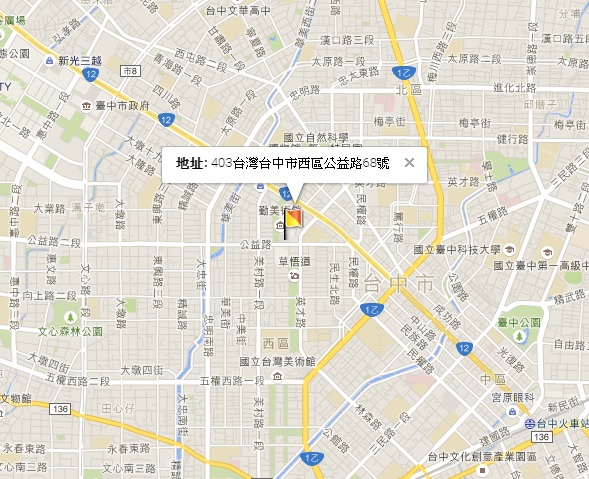
(實作範例地址為勤美綠園道)
「google_map.php」
<!DOCTYPE html>
<html>
    <head>
        <meta charset="utf-8" /> <!--語系UTF-8-->
    </head>
    <body>
        <style>
            /*設定gmap_canvas顯示區(寬與高)*/
            #gmap_canvas{
                width:100%;
                height:30em;
            }
        </style>

        <!--地圖顯示區-->
        <div id="gmap_canvas"></div>

        <?php
        //-----Google map value Start-----
        $set_address="台中市西區公益路68號"; //填寫所要的地址,Example地址為勤美綠園道
        $data_array = geocode($set_address);
        $latitude = $data_array[0];
        $longitude = $data_array[1];
        $data_address = $data_array[2];
        //-----Google map value End-----

        //-----function start-----
        function geocode($address){
            /*用來將字串編碼,在資料傳遞的時候,如果直接傳遞中文會出問題,所以在傳遞資料時,通常會使用urlencode先編碼之後再傳遞*/
            $address = urlencode($address);

            /*可參閱:(https://developers.google.com/maps/documentation/geocoding/intro)*/
            $url = "http://maps.google.com/maps/api/geocode/json?address={$address}&language=zh-TW";

            /*取得回傳的json值*/
            $response_json = file_get_contents($url);

            /*處理json轉為變數資料以便程式處理*/
            $response = json_decode($response_json, true);

            /*如果能夠進行地理編碼,則status會回傳OK*/
            if($response['status']='OK'){
                //取得需要的重要資訊
                $latitude_data = $response['results'][0]['geometry']['location']['lat']; //緯度
                $longitude_data = $response['results'][0]['geometry']['location']['lng']; //精度
                $data_address = $response['results'][0]['formatted_address'];

                if($latitude_data && $longitude_data && $data_address){

                    $data_array = array();

                    //一個或多個單元加入陣列末尾
                    array_push(
                        $data_array,
                        $latitude_data, //$data_array[0]
                        $longitude_data, //$data_array[1]
                        '<b>地址: </b> '.$data_address //$data_array[2]
                    );

                    return $data_array; //回傳$data_array

                }else{
                    return false;
                }

            }else{
                return false;
            }
        }
        //-----function end-----
        ?>
    </body>
</html>

<!-----google map Start----->
<!--可參閱:(https://developers.google.com/maps/documentation/javascript/3.exp/reference)-->
<script src="http://maps.google.com/maps/api/js?language=zh-TW"></script>
<script>
    function init_map() {
        /*地圖參數相關設定 Start*/
        var Options = {
            zoom: 14, /*縮放比例*/
            center: new google.maps.LatLng(<?php echo $latitude; ?>, <?php echo $longitude; ?>) /*所查詢位置的經緯度位置*/
        };

        map = new google.maps.Map(document.getElementById("gmap_canvas"), Options);
        /*地圖參數相關設定 End*/

        /*自行設定圖標 Start*/
        var image = {
            url: 'https://google-developers.appspot.com/maps/documentation/javascript/examples/full/images/beachflag.png', /*自定圖標檔案位置或網址*/
            // This marker is 20 pixels wide by 32 pixels high.
            size: new google.maps.Size(20, 32), /*自定圖標大小*/
            // The origin for this image is (0, 0).
            origin: new google.maps.Point(0, 0),
            // The anchor for this image is the base of the flagpole at (0, 32).
            anchor: new google.maps.Point(0, 32)
          };

        marker = new google.maps.Marker({
            map: map,
            position: new google.maps.LatLng(<?php echo $latitude; ?>, <?php echo $longitude; ?>), /*圖標經緯度位置*/
            icon: image
        });
        /*自行設定圖標 End*/

        /*所查詢位置詳細資料 Start*/
        infowindow = new google.maps.InfoWindow({
            content: "<?php echo $data_address; ?>"
        });

        infowindow.open(map, marker);
        /*所查詢位置詳細資料 End*/
    }

    /*
    事件偵聽器
    (可參閱:https://developers.google.com/maps/documentation/javascript/events)
    */
    google.maps.event.addDomListener(window, 'load', init_map);
</script>
<!-----google map End----->
執行後畫面如下: